Castner Scrapbook v.20, Delaware River 1, page 28
Historical Images of Philadelphia Castner Scrapbook Collection
Item Info
Historic Street Address: Penn's Landing
Media Type: Scrapbooks
Source: Print and Picture Collection
Notes:
Item 1, top: Image of a new ship being launched from the Cramp & Sons Shipbuilding Co.'s extensive wharves on the Delaware River, between Norris Street and then-York Street (today, the lower half of the Old Richmond waterfront area). The company produced ships of many kinds from 1830-1927. Starting small and rapidly growing by the 1860s-1870s, Cramp & Sons became among the largest producers of cargo ships, passenger ships, icebreakers, and colliers; and in 1862, they began producing iron battleships and gunboats for the US Navy. This engraving, while undated, depicts the launch of a large ship, and the construction of a much larger one to its left, placing its time period during the company's heyday. The image shows in great detail the bustling activity at the shipbuilding wharves, and numerous rowboats on the Delaware River. Engraving produced by the Philadelphia Photo-Electrotype Co. for an unidentified publication, 17 x 10 cm, undated (likely c. 1870).
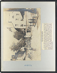
Item 2, bottom: Image of a paddle steamer and a rowboat on the Delaware River, looking across to Camden, NJ, viewed from the Philadelphia shoreline. A telescope, a standing light fixture, and a partially obscured sign are in the foreground; the developed Camden waterfront is in the background. The steamer pictured in the center was most likely one of the many ferryboats operating between Philadelphia and Camden during this period. The sign at the bottom of the image suggests ferry service to Camden that connected with a New York railroad line. Penn's Landing in Philadelphia was the chief location in the 1850s for numerous ferry lines to Camden, with two-- the Walnut Street Ferry or the Cooper's Point Ferry--providing direct railroad connections. (See this 1855 map: https://www.philageohistory.org/rdic-images/view-image.cfm/barnes;jsessionid=F62F7383EED903D7587B6DAECD25B61E.cfusion?CFID=121849499&CFTOKEN=b214360d3b006746-BA4DC69F-155D-010A-02AAADC7E063467C ) A faintly-pencilled "1853" on the lower left corner denotes the probable date of the engraving. Engraving for an unidentified publication,23.5 x 17 cm, 1853.
Creation Year: 1845
Geocode Latitude: Geocode Longitude:-75.140334
Geocode Latitude:39.949875
Call Number: A917.481 P536 v.20
Creator Name: Castner, Samuel, Jr., 1843-1929 - Compiler
Philadelphia Photo-Electrotype Co. - Engraver
 inside front cover
  0
0  1c
1c 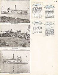 1
1 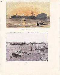 2
2 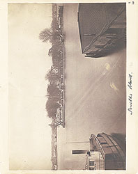 3
3  4
4  5
5 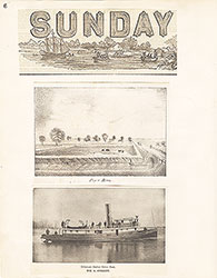 6
6  7
7  8
8  9
9 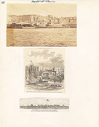 10
10 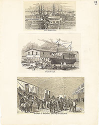 11
11  12
12  13
13 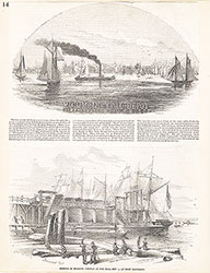 14
14 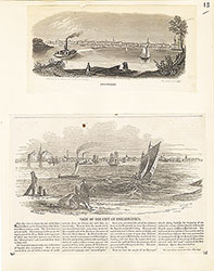 15
15  16
16  17
17 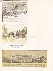 18
18  19
19  20
20  21
21  22
22  23
23 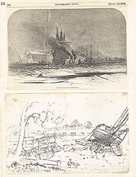 24
24  25
25 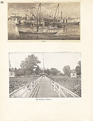 26
26  27
27  28
28
 29
29  30
30 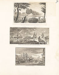 31
31  32
32  33
33  34
34 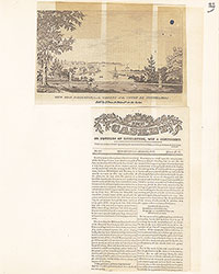 35
35  36
36 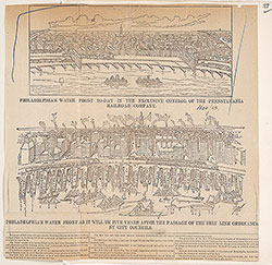 37
37 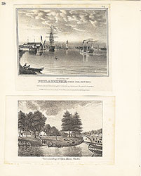 38
38  39
39  39
39  40
40 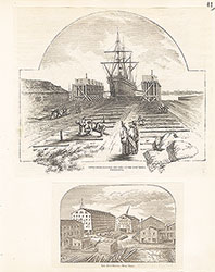 41
41  42
42  43
43  44
44 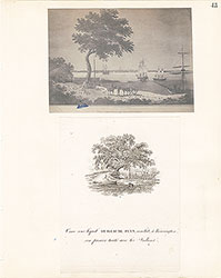 45
45  46
46  47
47  48
48 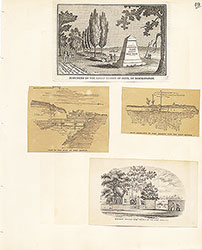 49
49  50
50  51
51  51
51 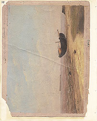 52
52  53
53  53
53 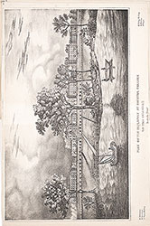 53
53  54
54  55
55 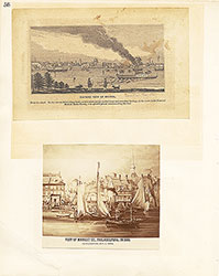 56
56  57
57 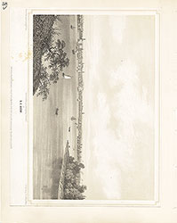 58
58 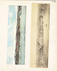 59
59  60
60  61
61 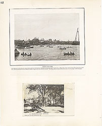 62
62  63
63  64
64  65
65  66
66  67
67 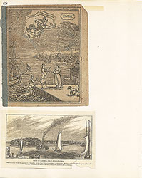 68
68  69
69  69
69  69
69  70
70 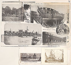 71
71  72
72  73
73  74
74 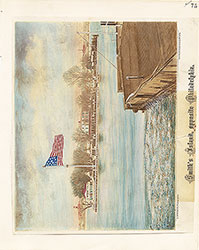 75
75 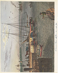 76
76  77
77 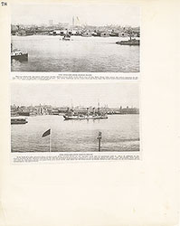 78
78  79
79  80
80  81
81 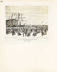 82
82 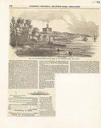 83
83 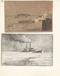 84
84  85
85  86
86  87
87 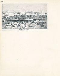 88
88 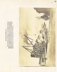 89
89  90
90  91
91 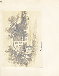 92
92 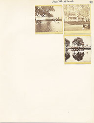 93
93  64a
64a