[Christopher Robin's Map]
From Our Collections![[Christopher Robin's Map]](https://media.freelibrary.org/assets/digital/items/foc000222/images/large.jpg "Click to zoom in on this image")
Item Info
Source: Children's Literature Research Collection
Notes:
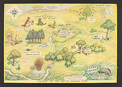
Based on the endpaper map (ink on paper) first depicted in:
A. A. Milne, Winnie-the-Pooh (London: Methuen & Co., LTD, 1926).
Notes:
Provenance: Gift of the Women's Club of Lawncrest, 1961
Notes:
This item was featured in the exhibition, Mapping Imagination: The Art of World-Building, Parkway Central Library, William B. Dietrich Gallery, March 2023-July 2023.
Notes:
Transcription
[Top corner compass] P [in space for North]; O [in space for both East and West]; H [in space for south].
[Locations identified on the map, from top to bottom, left to right:] Nice for piknicks [picnics]; To North Pole; Sandy pit where Roo plays; Bee Tree; Big Stones and Rox [rocks]; Pooh Bears house; Kangas house; Rabbits house; Rabbits frends [friends] and raletions [relations]; My house; Six pine trees; Owls house; Pooh trap for feffalumps; Piglets house; 100 Aker [Acre] Wood; Floody place; Where the Woozle wasn't; Eeyores Gloomy Place; Rather boggy and sad. [Dedication box] To the children of Philadelphia with friendly greets from the artist. Ernest H. Shepard August 1961; [Caption] Drawn by Me and Mr Shepard helpd [helped]
Creation Year (Single Year or Range Begin): 1961
Call Number: Shepard - Christopher Robin's Map
Creator Name: Shepard, E. H. [Ernest Howard], 1879–1976 - Artist
Milne, A. A. [Alan Alexander], 1882–1956 - Author
 [Christopher Robin's Map]