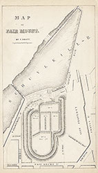
Map of Fair Mount [Reservoir and Dam], 1852, Map
Maps![Map of Fair Mount [Reservoir and Dam], 1852, Map](https://media.freelibrary.org/assets/digital/items/map00000076/images/large.jpg "Click to zoom in on this image")
Item Info
Item No: MAP00000076
Title: Map of Fair Mount [Reservoir and Dam], 1852, Map
Publication Year:
1853
Page: 1
Work Type: General Maps
Source: Map Collection
Notes:
Plan of reservoir and Dam. From the Annual Report of the Watering Committee for the year 1852
Northside Orientation of Image: Top
Alternate Page Number: Map
City/Town/Township: Geographic Coverage State/Province:Pennsylvania
Geographic Coverage City/Town/Township:Philadelphia
Geographic Coverage Note:Schuyklill River
Creator Name: Graff, Frederick, 1817-1890 - Engineer
Subjects
 Map
Map