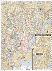
PTC Street and Transit Map of Philadelphia Showing Street Car, Bus and Subway-Elevated Lines, 1964, Directory
Maps
Item Info
Item No: MAP00000060
Title: PTC Street and Transit Map of Philadelphia Showing Street Car, Bus and Subway-Elevated Lines, 1964, Directory
Publication Year:
1964
Page: 60
Work Type: Transportation Maps
Source: Map Collection
Notes:
18th revised edition. Parks and recreation and museums, art galleries, theatres, hotels, department stores, hospitals, places of historical and general interest in central-city
Alternate Page Number: Directory
City/Town/Township: Geographic Coverage State/Province:Pennsylvania
Geographic Coverage City/Town/Township:Philadelphia
Creator Name: Philadelphia Transportation Company - Publisher
Subjects
 Map
Map 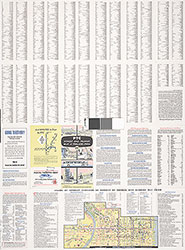 Directory