Nirenstein's 69th Street, Upper Darby [PA] Business Section, 1950, Key
Maps 1950: Nirenstein's 69th Street, Upper Darby [PA] Business Section![Nirenstein's 69th Street, Upper Darby [PA] Business Section, 1950, Key](https://media.freelibrary.org/assets/digital/items/mnbmad00002/images/large.jpg "Click to zoom in on this image")
Item Info
Item No: MNBMAD00002
Title: Nirenstein's 69th Street, Upper Darby [PA] Business Section, 1950, Key
Additional Title: Nirenstein's 69th Street, Upper Darby [PA] Business Section, 1950
Publication Year:
1950
Page: 2
Work Type: Business Occupancy Maps
Source: Map Collection
Northside Orientation of Image: Top
Alternate Page Number: Key
City/Town/Township: Geographic Coverage State/Province:Pennsylvania
Geographic Coverage City/Town/Township:Philadelphia
Geographic Coverage Region/County:Philadelphia
Creator Name: Nirenstein, Nathan - Publisher
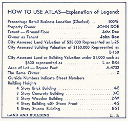 Key
Key
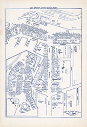 Plate 1