Neighborhood Beginnings: 11 Things You Should Know About Mt. Airy
By AdministratorIn preparation for a special Free Library event taking place this Wednesday, January 15 at Lovett Library, today we'll be looking at the history and architecture of Mt. Airy. The neighborhood has a fascinating history, along with many fabulous houses, structures, and landmarks. Who designed and built these houses, and created what we know as Mt. Airy? Read below to discover more!
In the late 1600s, the area northwest of William Penn’s "greene country towne" was called The German Township, and eventually, Germantown. It was less a town than a large rural area dotted with farms and small villages. Settlers built mills along the streams, including America’s first paper mill. The area became a center for weaving and selling linen cloth.
By the middle of the 18th century, wealthy Philadelphians began to build country estates in the Germantown hills as an escape from the heat and disease of the crowded city. One of the first was William Allen, a wealthy merchant who was the 26th mayor of Philadelphia and Chief Justice of the Pennsylvania Supreme Court for over 20 years. In 1750, Allen built a large stone house on 47 acres adjacent to Germantown Pike. Allen called his estate Mt. Airy and the road that bordered the estate on one side became Mt. Airy Avenue. The lane opposite his front door became known as Allen’s Lane.
Allen was a major figure in Philadelphia and a benefactor to many institutions, including Pennsylvania Hospital and the University of Pennsylvania. He sympathized with the colonists' complaints, but he feared the Declaration of Independence would lead to anarchy. His loyalist beliefs and failing health led him to resign as Chief Justice in 1774 and go to London. Allen’s mansion was demolished in 1848. In 1889, it became the site of the Lutheran Theological Seminary, now part of the United Lutheran seminary. The property has recently been designated a historic district.
Over time the villages and estates of Germantown began to consolidate into three main areas: Germantown to the south, Chestnut Hill to the north, and Mt. Airy in the center. Mt. Airy absorbed the former villages of Pelham and Beggarstown, also known as Dogtown, as well as Blue Hill and Devilstown. In 1854, Philadelphia consolidated all land within Philadelphia County into the city. Chestnut Hill, Mt. Airy, and Germantown made up Ward 22.
Textiles were a way of life in this part of town well into the 20th century. One example is Glen Echo Mills, built in the early 1800s at what is now the intersection of Carpenters Lane and Lincoln Drive. By the mid-1800s it was the largest mill of its kind in Pennsylvania. Glen Echo produced wool army blankets during the Civil War and later made carpets. It was demolished in the early 1900s to make way for Lincoln Drive.
At the time of the Consolidation Act, north Philadelphia was rapidly becoming an industrial powerhouse and Ward 22 was seen as prime land for suburban development. In 1859, streetcars, each drawn by 4 horses, began operating up and down Germantown Avenue between the city and Mt. Airy. In 1906, these same streetcars were electrified and became known as "dinkys." Each dinky had an iron-framed net on the front to scoop up anyone who was in danger of being run over. It took an hour and a half to get from Mt. Airy to Center City on a dinky.
In 1875, the Philadelphia and Reading Railroad hired Frank Furness to design Mt. Airy Station, one of over 125 he worked on. The station features a gabled roof with Queen Anne Stick-style architecture and is on the national historic register. Furness also designed several homes in Mt. Airy.
The late 19th and early 20th century saw Philadelphia’s most prestigious architects and builders hard at work in Mt. Airy. Among the first were Herman Wendel and Willard Smith, who built Pelham in West Mt. Airy. Between 1894 and mid-1917, Willard and Smith built over 300 buildings, including designs by Horace Trumbauer, William L. Price, Charles Barton Keen, and Frank Mead. Homes were placed on large lots along wide curving streets. They include many architectural styles such as Colonial Revival, Jacobean, Italianate, Queen Anne, Greek Revival, and Dutch Colonial, all constructed of Wissahickon schist, brick, or stucco. East Mt. Airy development included the James Gowen Estate on Gowen Avenue and Aston Tourison’s Sedgewick Farms, which features many Tudor Revival homes.
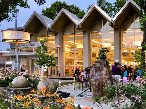
Aston Tourison also designed the Lovett Memorial Library at Germantown Avenue and West Sedgewick St. in the 1880s. The library, a branch of the Free Library of Philadelphia since 1924, has been enlarged and renovated more than once. The original library is now a meeting room.
It was residents of Pelham who established the Automobile Club of Germantown in 1905. They built a clubhouse across from the Carpenter Lane train station. The building featured large rooms for social events, smaller rooms for cards and pool, a bowling alley, and a 24-car garage complete with a full-time mechanic. The building is now The Commodore Barry Arts and Cultural Center which celebrates Irish culture.
Post-WWII, Mt. Airy was a stable middle-class community with good schools and diverse housing stock. Over 98% of the residents were white. Like many in similar communities across the northern U.S., they were concerned that the large influx of African Americans from the south would change their neighborhood. Unlike most of those in other communities, residents of Mt. Airy decided to protect their neighborhood by welcoming change rather than fighting it. Led by clergy from the Germantown Jewish Centre, the Epiphany Episcopal Church, the Unitarian Church of Germantown, and Summit Presbyterian Church, as well as working with Philadelphia’s Commission on Human Relations, Mt. Airy marketed itself as an integrated neighborhood. Since then, other community organizations such as West Mount Airy Neighbors and East Mt. Airy Neighbors have taken the lead and expanded efforts to include all forms of diversity. Mt. Airy is now one of the most diverse and stable areas in Philadelphia.
Further Reading

Remembering Germantown: Sixty Years of the Germantown Crier edited by Judith Callard and Irvin Miller

Making Good Neighbors: Civil Rights, Liberalism, and Integration in Postwar Philadelphia by Abigail Perkiss
The Definition and Analysis of Stable Racial Integration: The Case of West Mt. Airy, Philadelphia by Leonard Franklin Heumann
The History of Mt. Airy: A Tour of Tourison will take place Wednesday, January 15 at Lovett Library at 7:00 p.m. The event is free and open to the public.
Have a question for Free Library staff? Please submit it to our Ask a Librarian page and receive a response within two business days.